

About this print
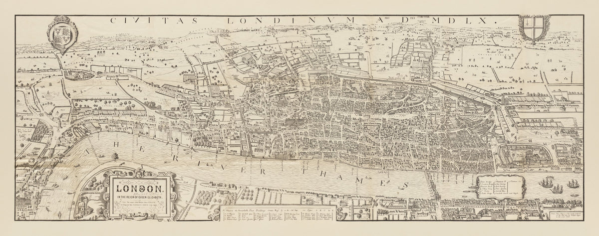
Civitas Londinum — Reduced Victorian facsimile of the "Agas" woodcut map, published by Cassell, Petter & Galpin, London.
A bird's-eye view of Elizabethan London: the walled city, the Thames and old London Bridge, Southwark and the fields beyond. Issued with part 67 of Cassell's Old & New London. A note on the sheet credits Ralph Aggas and the year 1560, an attribution now doubted, and the names of modern sites such as Waterloo Bridge and Soho Square are engraved among the old streets. A long panoramic sheet.
The woodcut map shows London early in Elizabeth I's reign. St Paul's appears without its spire, lost to fire in 1561, so the map can be no earlier than that year. It was cut on eight wood blocks as a slightly cruder copy of the 'Copperplate' map surveyed between 1553 and 1559, which survives only in part. Only three impressions of the original are known, all printed in the seventeenth century.
Cassell, Petter & Galpin issued this reduction with Old and New London, a six-volume history of the city by Walter Thornbury and Edward Walford published from 1873. The three full-size originals are held by The London Archives, the Pepys Library at Magdalene College, Cambridge, and The National Archives at Kew.
Original held by the Norman B. Leventhal Map & Education Center, Boston Public Library. Restored by Limner from the library's scan, its two sections joined; nothing redrawn.
Look closer
-

The title cartouche
The cartouche reads "London in the Reign of Queen Elizabeth". A note says modern sites are engraved "thus: WATERLOO BRIDGE, Soho Square"; Regents Park and Pentonville appear this way near the top.
-

Bull and bear baiting
South of the river, two round arenas are labelled "Bull Bayting" and "Bear Bayting", bulls to the west and bears to the east. The Survey of London places these baiting rings on Bankside, in Southwark.
-

The facsimile note
A note reads "This Map is a Fac-simile (reduced) of the Old One by Ralph Aggas in the year 1560". It is recorded as issued with part 67 of Cassell's Old & New London; the Agas attribution is now doubted.